La Niña is over. It only lasted a few months, but tropical warmth is taking over again. While the Pacific will probably hover in the neutral territory between La Niña and El Niño into the summer, some models are hinting El Niño could return as early as this summer.
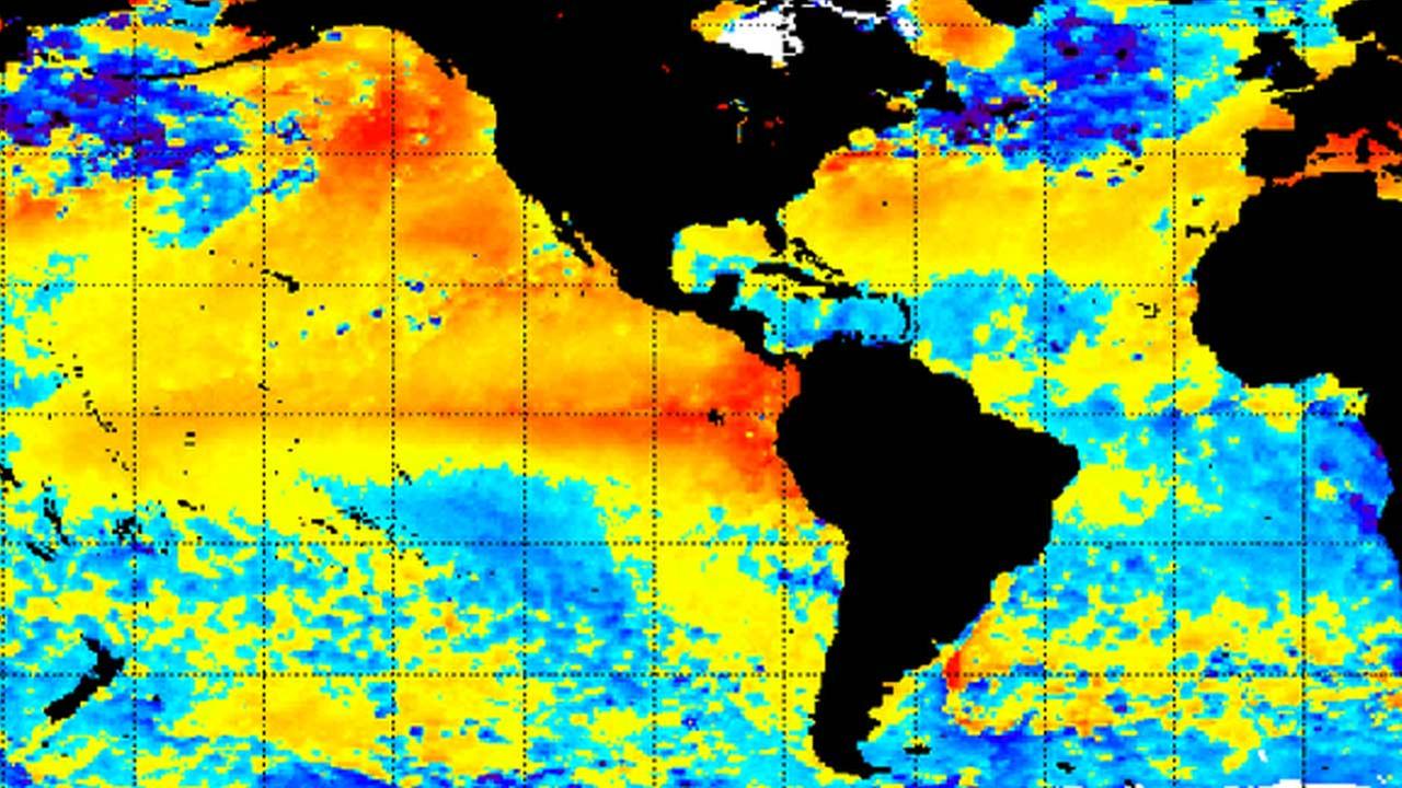
El Niño occurs when warmer than average water is consistently observed in the tropical Pacific. A wide variety of weather and climate connections appeared during the most recent (Godzilla) El Niño, including a below-normal hurricane season in 2015, a record-shattering 2015 Northeast Pacific hurricane season and record-high global temperatures.
Often following a strong El Niño event, the Pacific swings like a pendulum to a strong La Niña event, which is characterized by much colder than average water. While we briefly ventured into weak La Niña territory over the past few months, NOAA has just declared that the region is neutral again. Right at this very moment, we are in neither La Niña nor El Niño.
There is considerable uncertainty as to what will transpire next. The European forecast model is generally considered to be the most reliable for predicting El Niño. It is fairly aggressive at calling for warming conditions in the tropical Pacific over the next few months — possibly by July. All of the models that try to predict El Niño use “ensemble” forecasts. In the case of the European model, there are 50 different runs of the same model with slightly different input conditions; this attempts to account for the natural chaos of the atmosphere and gives us a better idea of what the possibilities are.

Forecasts from the ECMWF model for the Niño 3.4 region, which is a region near the equator in the east-central tropical Pacific that is used by NOAA and other groups to declare El Niño or La Niña events. (ECMWF)
There are a wide variety of other dynamical and statistical models that predict future El Niño conditions. Dynamical models use current observations and equations that govern the atmosphere and ocean to forecast the tropical Pacific, while statistical models use historical relationships and past data to forecast future conditions.
The ECMWF model is on the aggressive side of the spectrum, with many other models forecasting neutral conditions (near-average SSTs). The consensus of the current suite of ENSO models is for somewhat less warming than what is predicted by ECMWF.
But, given all this, spring has a “predictability barrier” for El Niño. Models don’t do as well during this time as they do during other seasons. This is primarily due to the fact that the low-level winds that blow from east to west across the tropical Pacific are at their weakest during this time of year, and consequently, small atmospheric changes can cause significant cooling or warming of the tropical Pacific. Those are hard things for big global models to pick up on.
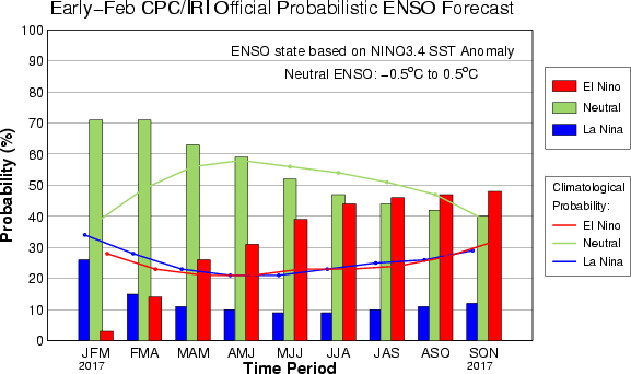
As of early February, NOAA calls for a 45 percent chance of neutral conditions from July to September, and a 45 percent chance of El Niño. There’s just a 10 percent chance of La Niña, NOAA forecasters say.
As you can see from the variety of model forecasts and official forecasts that are available, there is considerable uncertainty as to what conditions will look like in the tropical Pacific this summer. As we move further into the winter and into the spring, the skill of forecasts for the tropical Pacific should improve significantly, yielding greater confidence as to whether El Niño will develop this summer.
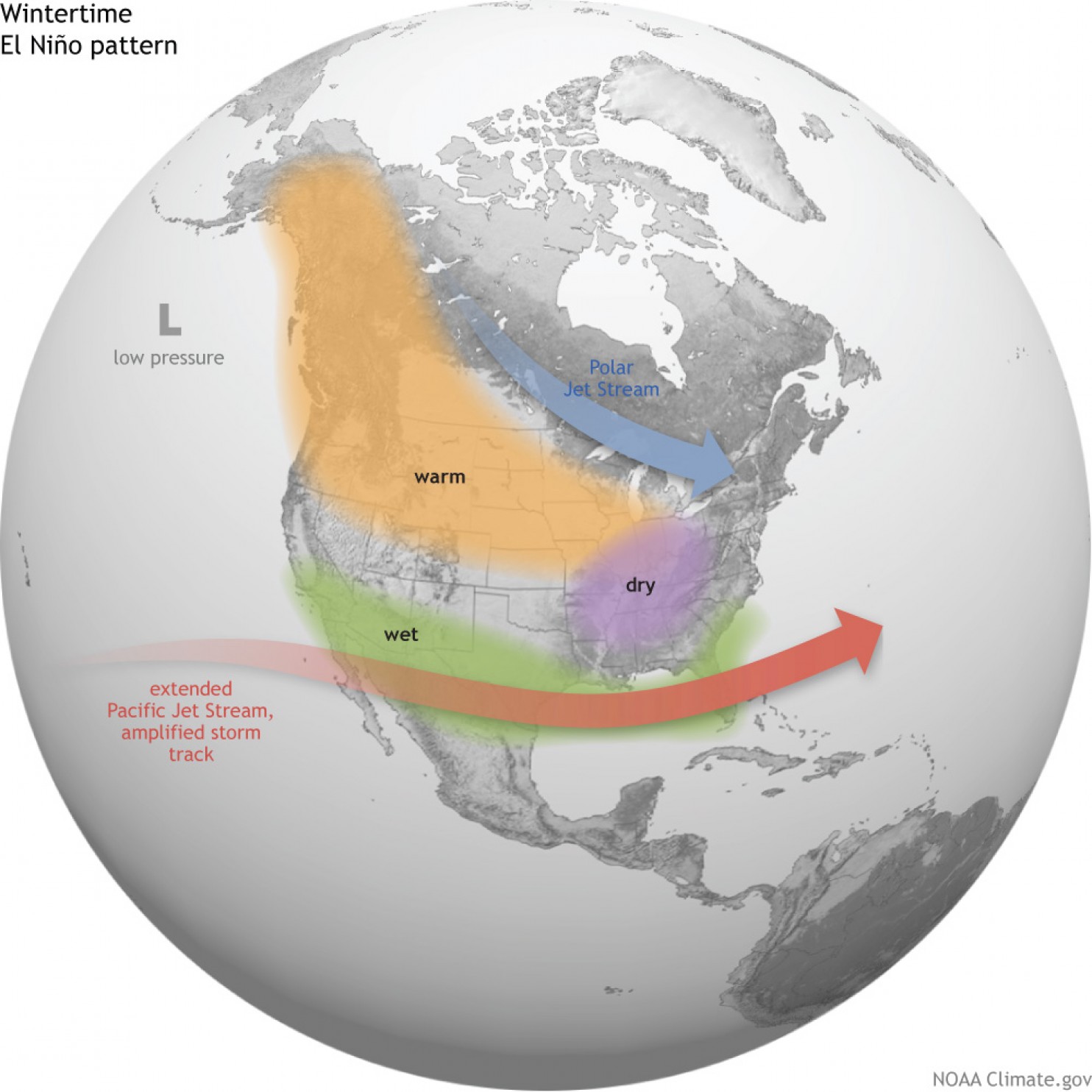
If El Niño were to develop quickly this year, it could potentially reduce levels of Atlantic hurricane activity this summer. While El Niño’s impacts on summer weather in the United States are not particularly strong, it has significant impacts on winter weather. In general, El Niño winters are characterized by enhanced moisture across the southern tier because of a stronger-than-normal subtropical jet stream. The northern states experience warmer-than-normal temperatures in El Niño, with anomalously dry conditions experienced across the Ohio Valley.
Of course, all of these potential impacts hinge on whether El Niño actually develops. At this point, it is a possibility by the end of 2017.
